
Join us on

Please visit the Sitemap to see the full range of information on this site
MountainWalk.co.uk is produced by Trish Haill Associates Copyright
Have you climbed Ben Nevis, Snowdon or Scafell Pike? Or taken part in the Three Peaks Challenge? Or have a special walk you'd like to share? We'd love to here from you! Join us on Facebook or Send us an email.
Ascending Snowdon via the Miners Track and returning by the Rangers Path
Many thanks to Glyn Williams for this description of his walk up the Miners Track, returning via the Rangers Path. Credit also to Glyn for such beautiful photographs!
Snowdon Conquered at Last
Yesterday (06/06/2011) my son and myself climbed Snowdon, I am 63 years old and have lived in Wales all my life, the last 35 years or so in North Wales. It has always been a regret of mine that I had never been up Snowdon and it was something I had wanted to do for many years, but for a variety of reasons just never got around to it.
In my job I used to drive around North Wales and could see Snowdon from many different angles, I have numerous photographs showing it on lovely clear days some on less clear days and some with it covered in snow.
In my job I used to drive around North Wales and could see Snowdon from many different angles, I have numerous photographs showing it on lovely clear days some on less clear days and some with it covered in snow.
At last yesterday everything worked out and my son and myself set off along the Miners Track. The scenery, almost from the start, is outstanding and the path is pretty gentle. However after Llyn Glaslyn things start to get a bit more serious, the scenery - if it were possible - gets better and the track gets considerably more challenging.
Eventually you join with the Pyg track and you realize the summit is not too much further. After some more heaving breaths and aching muscles you reach the top of the track and you feel a welcoming cooling breeze (we went up on a warm day) and the panorama that opens up before you can only be described as spectacular, after you taken some time to take in the views and get your breath back it's a relatively short climb to the cairn on the summit.
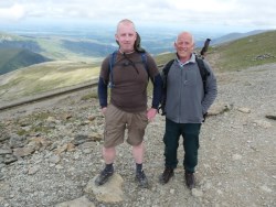
Glyn and Rhodri
We sat on the grass and had a welcome picnic lunch, soaked up the scenery and took some photos, then we set off to descend via the Snowdon Ranger path. This starts off fairly gently but quite quickly descends steeply where the path is of loose scree and it would be easy to slip. After the descent the path levels out to a nice gentle walk back to bus stop, all the way down we kept looking back at the summit with a fair amount of satisfaction to think we had at last managed something we had wanted to do for years.
If you have been thinking about doing it but keep putting it off, I would urge to go and do it, the amount of self satisfaction is well worth the effort.
I don't know if it's the hardest thing I've ever done but it's certainly in the top two.

View back down the Miners Track
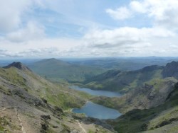
View from the summit
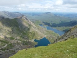
View from the Rangers Path
Glyn on Miners Track
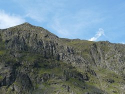
The Ranger Track
David from Tennessee says:
I managed to solo climb the Ranger Track route to the top of Mt. Snowden in October, 2007. We had rented a cottage in Trevriew and I caught the train to Betys-Y-Coed and then the bus on to the Hostel parking lot. I found the trek exhilarating and beautiful, and not exhausting at all. As I neared the top, however, I found myself walking more and more into a thick cloud bank, and after a while it became somewhat difficult to find the trail nearing the top of the mountain. By the time I reached the cairn at the summit, it was similar to standing in a thick soup, with no visibility at all. Due to the limited vision, I took no pictures at the summit, although NOW I wish I had at least had someone take my picture in the fog by the cairn. A friendly couple did take my picture for me on the hike up the trail, probably about half-way up. I hope to someday return and repeat the trail, hoping for a view of some sort at the top--perhaps when my granddaughter is old enough to make the hike the two of us will go.
The trek back down the mountain seemed harder than the trek up, perhaps owing somewhat to fatigue. I also suffered a toe injury, somewhat like "turf toe" on the way back down, and that slowed me up a bit. It was a wonderful view to round the last bend and see the hostel far below. I waited at the hostel for the bus, which picked me up and returned me, with only one changeover, back to Trevriew.
How to get to Snowdon and Where to Stay
Snowdon Facts and History
Snowdon Weather
Walking Equipment
Fitness Required
Holidays in Snowdonia
Mining on Snowdon
Snowdon Facts and History
Snowdon Weather
Walking Equipment
Fitness Required
Holidays in Snowdonia
Mining on Snowdon