

Join us on

Please visit the Sitemap to see the full range of information on this site
MountainWalk.co.uk is produced by Trish Haill Copyright
Have you climbed Ben Nevis, Snowdon or Scafell Pike? Or taken part in the Three Peaks Challenge? Or have a special walk you'd like to share? We'd love to here from you! Join us on Facebook or Send us an email.
Snowdon - Rhyd Ddu Path
Rhyd Ddu Path
One of Snowdon's best kept secrets, a lesser used (though just as scenic and enjoyable) where you can escape the crowds as you head to the summit of Snowdonia's highest mountain.
Apart from one or two short steep climbs, this wonderful route makes for a fairly gentle outing on Snowdons quietest side. The route is gentle at first and crosses some rough, sometimes pathless, often boggy ground. But, with the scenery growing in grandeur all the time and a wonderful sense of remoteness building with every step taken, its well worth the effort. Yr Aran and Snowdons South Ridge look impressive early on, but the best is yet to come
Moel Hebog and the Nantlle Ridge, first glimpsed in all their splendour as you ascend Llechog. And, as if that wasnt enough, the highlight of the day has to be the crossing of Bwlch Main. This exposed, narrow ridge makes for an exciting and exhilarating, but safe, final ascent to the summit with breathtaking views in all directions.
| Start/Finish | Rhyd Ddu carpark (SH 571 527) |
| Distance | 14.5km (7.5 miles) |
| Walking time | 6 - 7 hours |
| Total ascent | +890m (+2929ft) |
| Terrain | Good paths; gradual ascent at first; steep and exposed final section |
| Difficulty | Easy/Medium |
| Maps | OS Explorer OL17; OS Landranger 115; Harvey XT40 |
| Parking | Rhyd Ddu Car Park (SH 571 527) postcode LL54 6TN |
| Public transport | Sherpa Bus: Stops at the end of Rhyd Ddu Car Park |
Map, pictures and text kindly provided by Snowdon Walks. A blog dedicated to climbing Snowdon.
Snowdon is an incredibly popular mountain with hoards of walkers arriving each morning to tackle its legendary routes. But it is possible to find solitude here. It is possible to have this beautiful mountain almost to yourself.
Take your time: enjoy the scenery and dont forget to turn round every now and then to appreciate the vista behind you - the meandering nature of this walk means the scenes are constantly changing.
Take your time: enjoy the scenery and dont forget to turn round every now and then to appreciate the vista behind you - the meandering nature of this walk means the scenes are constantly changing.
The Rydd Ddu Route
Start - Rhyd Ddu car park, A4085, LL54 6TN (Grid ref: SH 571 525)
Take the path, north, leaving the car park walking past the public toilets. Turn right after 100m crossing the railway line through the gates. Follow the gravely path, keeping right, passing through the remains of the Ffridd Slate Quarry. Stay on the track for the next 1km passing through a couple of gates towards Pen ar Lon.
Left-hand gate (Grid ref: SH 582 524)
Leave the gravel track and go through the gate on your left. Continuing along the gravel track will take you to Bwlch Cwm Llan and the start of the South Ridge route.
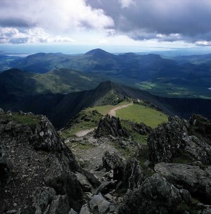
Through the gate the terrain is flat, rushy and boggy in places. A gradual ascent takes you north-east through the Cwm Caregog. Head through another gate and continue until reaching the remains of an old stone building. It is at this point where the path becomes rugged and steeper.
Ascent of Llechog (Grid ref: SH 592 534)
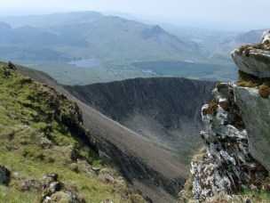
The path quickly steepens as you clamber up the rocky shoulder of Llechog Ridge. Follow the path up the shoulder taking care on the tricky sections. When reaching the top you will see the Snowdon summit building and clearly see the route to the summit.
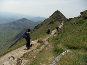
Llechog Ridge (Grid ref: SH 596 538)
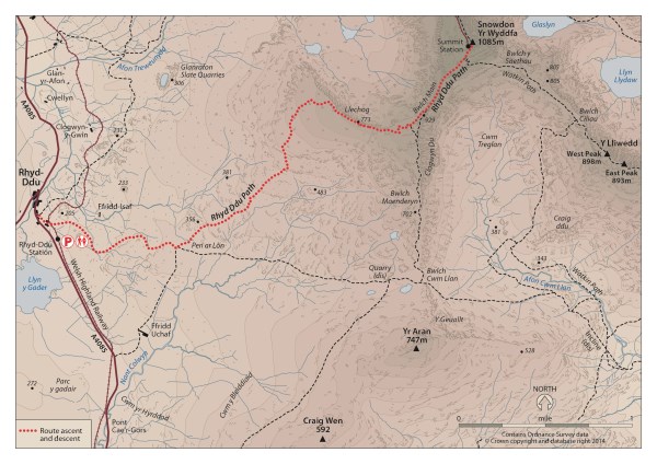
Keeping to the path, head east along the ridge, through the gate, and towards the highest point of the ridge where the South Ridge and Bwlch Main connect. The views from this point are breathtaking especially looking down in to Cwm Clogwyn and over towards the Snowdon Ranger Path.
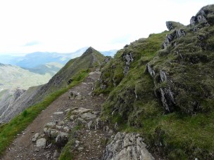
Rhyd Ddu Zigzags (Grid ref: SH 602 535)
The zigzag path is the steepest section of the route but also the most enjoyable as you make your way to Bwlch Main. Reaching the top is a tough slog but the views are well worth the effort.
Crossing Bwlch Main (Grid ref: SH 604 356)
The narrow ridge of Bwlch Main (narrow pass) is the highlight of the route. Although not a difficult ridge it is still exposed with steep slopes either side. Take care crossing the ridge and stick to the path. In bad weather, Bwlch Main can be daunting, especially if you have not tackled an exposed ridge before.
Many thanks to Snowdon-Walks.co.uk for providing the route details, maps and pictures for the Rhyd Ddu walk. Visit the blog for more information about climbing Snowdon.
Click on map for larger image
Summit push (Grid ref: SH 609 542)
Once over Bwlch Main the path rises again and joins the Watkin Path, marked by a large stone for the final 200m to the summit.
Follow the rugged path, following the marker cairns, towards the summit building walking directly past it and up the steps to reach the summit cairn.
The Descent:
The descent is straight forwards and follows the exact same route as the ascent. After crossing Bwlch Main ensure you turn right at point E to Llechog. Missing this turning will take you down to the South Ridge.