
Join us on

Please visit the Sitemap to see the full range of information on this site
MountainWalk.co.uk is produced by Trish Haill Associates Copyright
Have you climbed Ben Nevis, Snowdon or Scafell Pike? Or taken part in the Three Peaks Challenge? Or have a special walk you'd like to share? We'd love to here from you! Join us on
or Send us an email.
or Send us an email.
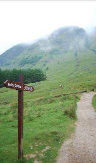
Climbing Ben Nevis is a challenge for anyone
....
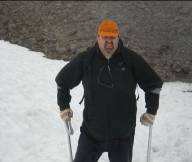
Ben Nevis on Crutches
Standing at 1344 metres (or 4408 ft in old money) the path up this mountain is steep and long.
It's a full day's hike, and all but the very fit will have aching, tired muscles at the end of it. Climbing the highest mountain in the British Isles is a great achievement - many people have tried to do it in different ways - by bicycle, car - or even carrying pianos!
But for some, it's a personal challenge to prove what they can do despite their own physical limitations and to raise money for others on the way.
Ex-serviceman Robin Beadle is one such person, and he's kindly given permission for his story to be shared on this site. Hopefully, this will be an inspiration to anyone wondering if this is something that they can attempt!
Robin's email to the Mountainwalk.co.uk website:
Last year I took on Ben Nevis again - this time successfully and having used your website in the planning stages (and now looking at it again to take on Scafell Pike) and seeing your request for stories I thought I would let you have mine.
I first climbed Ben Nevis the hard way in the mid-80s - I was in the Royal Air Force, and we took the back route to the summit at a run. Later while on leave I took the tourist route to the summit in the cloud. Prior to last year, my last attempt had been in the early 90s when the Ben obviously did not want to be climbed that day as a snowstorm hit while on the zigzags forcing a hasty retreat.
I first climbed Ben Nevis the hard way in the mid-80s - I was in the Royal Air Force, and we took the back route to the summit at a run. Later while on leave I took the tourist route to the summit in the cloud. Prior to last year, my last attempt had been in the early 90s when the Ben obviously did not want to be climbed that day as a snowstorm hit while on the zigzags forcing a hasty retreat.
And here is Ian's account
A personal view of the Ben Nevis Challenge
A band of less-than-wide-awake walkers arrived at the car park at 5.15am with 5 miles and a 4,409-foot summit ahead of them. The clouds sat over the mountains ahead of us but it was dry and the forecast for the morning was positive. As we started walking the world around us was silent other than the water passing under the bridge and each footstep on the footbridge. We make good progress as the morning starts to stir and the air begins to lose the chill of the early morning dew for the warmth of the early sun breaking through gaps in the cloud. After the stiles at the Nevis Inn, we had our first terrain change as the path changes from a relatively level even path into a steep, very uneven cobbled street.
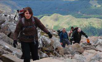
As we ascended the flanks of Meall an t-Suide (pronounced Melantee), the sheer effort and concentration Robin would need to complete this challenge started to become apparent as stones the size of cobbles started to become small boulders that had to be climbed over.
Harder on Crutches
Not only was Robin having to think where to put each foot for every step, but he also had to think and then check the placing of his two crutches, ensure there was room to move his damaged leg and then place his good leg to push his body up ready for the next step. Later in the day we said he should have had a pedometer so that we could report how many times this process had been completed during the challenge and the fact that he fell only twice (both times on the ascent) shows he rarely got it wrong.
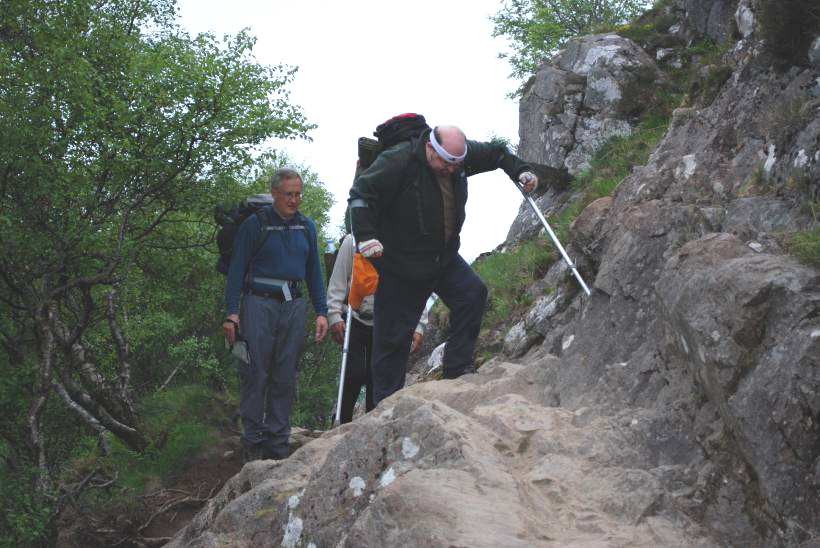
Robin, Ian & Steve climbing Meall an t-Suide.
Red Burn Gulley. Ben Nevis is on the left of the picture
On the Radio
BBC Radio Suffolk phoned at 6.30am to find out how the climb was progressing and I suspect for the first time ever had a weather forecast from Ben Nevis - a lot of use back in Suffolk!
After his crutches, his painkillers, and his water, the most important piece of kit was Robins £4 sweatband which kept the perspiration - no, sweat - out of his eyes. With each part of the climb, the sweat band was rung out. At regular intervals, Robin would talk to his bad leg like some slightly disobedient dog that wouldnt quite walk to heel. The most frequent phrase on the way up was this mountain isnt going to beat me (sometimes more colourfully said than others). Robin had tried once since leaving the RAF to climb Ben Nevis again but had had to turn back due to bad weather. This time, he was older, a bit heavier and his leg had deteriorated further. Hence it was now or never.
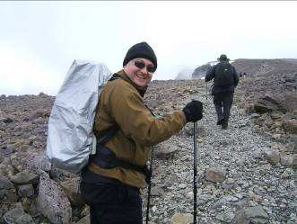
Adrian surveys the next stretch of path as Ben Nevis appears in the distance
The cobbled street continued up towards Red Burn and the half way mark. After climbing through the gully between Meall an t-Suidhe and Ben Nevis itself, the gradient eases as you pass onto the saddle between the two mountains. Around 1,750 feet by Lochan Meall we spotted a tent and two brave souls who must be midge proof as we had only just started to lose them above the loch. By now other walkers started to pass us on their way up. At this point tourism provided us, and Robin especially, with a welcome break: no, not a coffee shop but instead path erosion which had led to a man-made grit path, which was level (from side to side that is) and therefore the only easy part of the climb.

The going gets temporarily easier on the saddle
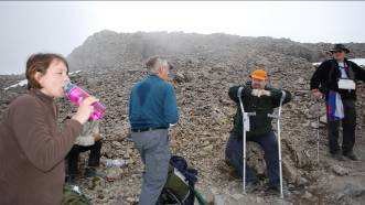
Halfway
We turned for Red Burn and the halfway mark, where we rested and refilled our supermarket spring water bottles with the real thing direct from a highland stream. Immediately after our rest, we rounded a corner and yes there was a mark of civilisation - a men-at-work sign. The warning was for path rebuilding work - not that we wouldnt have noticed it was all dug up, with one-ton bags of stone all along the side and a digger. No sign of any men-at-work this early in the day, though. The warning perhaps was justified as we walked up this unbuilt path, as it was worse than anything else we would encounter all day.
The sheer exertion needed by Robin to carry himself each step did result in much self-generated verbal encouragement. Steve and I would follow him step by step, a feat we did virtually all day, with Doug walking ahead pathfinding and Adrian and Karen walking a few paces in front. With the work involved Robin became a cloud in his own right with the steam rising through his fleece. As I watched this steam, I realised that if the terrain was this hard to climb up, technically it was going to be a lot harder going down - a thought I kept to myself.
As we ascended the cloud that had been keeping just above us for the first part of the climb decided to show us how quickly the mountain could reduce visibility, so out came the compasses but then just as quickly the cloud lifted and we could again follow the path.
Karen passes the height of Mount Snowdon
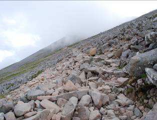
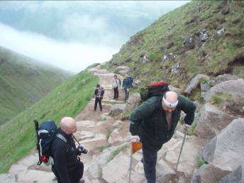
The zigzag path on Ben Nevis. The slightly lighter coloured rock is the path
Almost to the top of the zigzags, the team take a breather
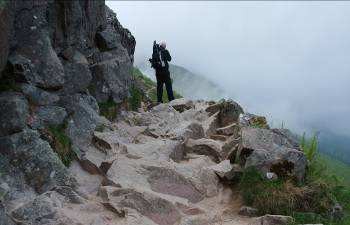
Adrian and Doug above McLeans Steep with the summit now half a mile away
The zigzags up the upper part of the mountain began to take their toll on Robin as the effort required to cross the rocks and climb some 1,500 feet in a relatively short horizontal distance is the toughest part of the climb. Steve, having decided to both maximise funds he would raise and experience his own unique brand of walking difficulty by trying to carry a case of Newcastle Brown up to the top, also began to find the climb harder work at this juncture. As we walked, we started to see patches of snow - winter was still very slowly giving over to spring - although the backdrop by this stage is very grey and rocky - no grass, so the remains of winter softened the landscape.
As we left the top of the zigzags and started out on the plateau, again the visibility fell to the point where we stopped and took our compass bearings thinking that this is going to get technical - but again the cloud cleared after a few steps not to trouble us again in this way.
The last part of the climb brought us to McLeans Steep, a 300-foot climb across a small snow field, down which some more active walkers were tobogganing using anything they had in their rucksacks like plastic bags or waterproof trousers. For us, however, the summit was now in sight.
Made it!
The last few hundred yards was comparatively easy walking but to our left was the sheer drop of Gardyloo Gully, which, without compass and map, could had the visibility been poor, have seen us make a rapid descent. Here, the frozen snow still capped the rock edge showing its windblown layers project out from the top of the rock face. A few more steps and the summit was reached. With modern technology, we set about letting people know we had reached the summit at about 1.15 pm after some 8 hours on the mountain and 7 hours walking. However on that day, only Vodaphone obliged with a reliable signal. We did the necessary photos and decided to tie the flag to the spare crutches strapped to my rucksack for the journey down.
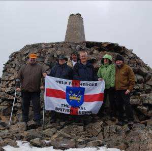
The whole team unfurl the flag
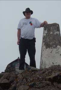
Doug at the summit trig point
The weather was reasonable, so we rested, ate and in some cases drank Newcastle Brown so Steve only had to carry nine full bottles and three empties back down, though that didnt make a huge difference to the weight in his rucksack. We then awaited the call from BBC Radio Suffolk and the Lesley Dolphin show, which with hindsight would mean we would be on the mountain later than we planned. But the rest did Robin good, and he got his time on the radio and even managed to give Ensors a plug - who says there is no such thing as free advertising!
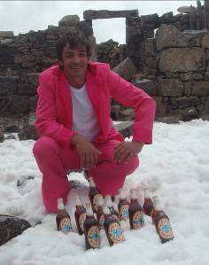
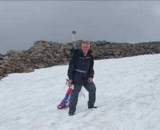
Newcastle Brown and a pink suit (dont ask)
The Descent
The happy band were ready for the off about 3 pm and down the first part made relatively good progress as while it was rocky, the incline wasnt too steep, and there were various predictions being back down by 6 or 7 pm. The snowfield was covered relatively easily, while watching a group of teenagers very energetically running back up the slope to keep sliding down though we were either too dedicated to the task to engage in such frivolous use of energy - or too tired (or too old) - Ill leave you to decide!
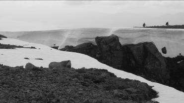
Gardyloo Gulley with snow even in June
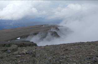
Cloud hits the edge of the plateau
As we approached the zigzags our pace slowed, as my thoughts of the morning became reality - going down was going to be more mentally tiring and physically hard on Robins legs than coming up. Again, each step had to be planned crutches positioned, tested leaning forward slightly as they were lower than his present position, move the bad leg and then drop down onto the good leg. As we slowly descended, I discovered you are never too old to learn new words in the English language, probably some code words the RAF had invented. The cloud had stayed above us keeping visibility good but it just couldnt resist dropping a gentle mist down on us, such that waterproof coats were needed all the way down. Like all good British people we had fallen back into our line (queue) for the descent with Doug pathfinding, Adrian and Karen going just ahead and Steve and myself just behind.
As we walked, the flag resulted in several people stopping and asking us about the walk and we actually collected some money. However the fact that there is no shop at the top meant many people had no cash. At this point late in the afternoon, there were still people going up including one group on a three-peaks challenge, but we knew by now they would pass again before we had reached the bottom of the mountain.
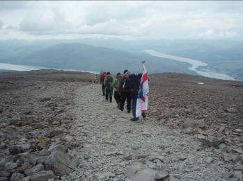
Leaving the plateau in formation
The descent was now proving very tiring for Robin, but there was no complaint because as he put it, he had beaten the bloody mountain. As we approached the Red Burn, yes, there was another men at work sign warning you of the path works, but there they were - men at work complete with the mini digger. They kindly stopped working and moved the digger to enable Robin to pass on the inside edge and as we passed the supervisor said that this was a good example to his two-man gang who were working summer evenings at Her Majestys suggestion! A brief stop was had at Red Burn as we reached the halfway stage, water bottles filled for the last time with real mountain stream water, the last rolls, and chocolate bars were eaten. Its a good job we burnt calories on the mountain as I realised I had consumed four rolls, three apples, three bags of nuts and raisins and eight chocolate bars during the day.
As we started the final descent through the gully, and onto the side of Meall an t-Suidhe, the midges returned with a vengeance, and we really werent in the mood as it was damp. We had been on the go for 14 hours, and the people we had seen ascending early in the afternoon were now passing us on the way down. Robin was still making each step in the same painstaking way and admitted that his leg was really screaming at him with the jolt of each step down.
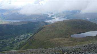
The mountain of Meall an t-Suidhe comes back into view on the way back down. Fort William hidden behind
About 8.30pm, we reached the last part of the descent towards the Nevis Inn, where we were passed by the three young lads, whom we had seen earlier in the day, pushing their mountain bikes up the mountain, riding down the very same path we were making our way down worried about each step. But they just bumped down rock by rock often on the outside edge with a long drop through trees beneath them if they left the path. Finally, as we expected the three-peaks group we had seen ascending in the late afternoon descended and left us as the last people on the mountain as the light started to fade, but with 45 minutes to go, we could now see the bottom.
Back Down
As we walked back in at 9.15pm Robin said to me; Did you think I would do it?
I replied Before today yes - without any doubts - but having seen you do it, with:
· The amount of time on the mountain - 16 hours
· The mental effort in planning each step up and especially down as tiredness set in
· The sheer physical exertion of each step
· The complexity of the terrain for someone on crutches one slip and it could have all been over .
Yes, I was amazed he had made it!
Ian Brookman,
Managing Partner, Ensors
Robin
Ian
Other pages you might like:
Ben Nevis Tourist Path
A Night on Ben Nevis
Ben Nevis Walkers share their stories
Three Peaks Part 1 - Ben Nevis
Pole Dancing on Ben Nevis
Ben Nevis c1960
Ben Nevis Tourist Path
A Night on Ben Nevis
Ben Nevis Walkers share their stories
Three Peaks Part 1 - Ben Nevis
Pole Dancing on Ben Nevis
Ben Nevis c1960
Fast forward to June 2010 and with advancing years and mobility problems, I have a team walking with me. As a group we would be travelling slowly on the climb so were prepared with extra rations, wet weather gear, torches, survival bags and the ever-smelly poncho (stick to the kit you know and trust). Despite the massive time taken to summit Ben Nevis, everyone in June walked on and off the mountain safely, no injuries (apart from the usual midge-bites) and we summited.
I was honoured to have a team of friends to help me tackle the hill and one of them, Ian Brookman, wrote a personal account on his train ride home. I enclose it for your reading. Final sum raised for charity exceeded £3,500. Your website (among others) helped us in the planning stages (and in convincing team members that they really did (or did not) want to do the walk).
I was honoured to have a team of friends to help me tackle the hill and one of them, Ian Brookman, wrote a personal account on his train ride home. I enclose it for your reading. Final sum raised for charity exceeded £3,500. Your website (among others) helped us in the planning stages (and in convincing team members that they really did (or did not) want to do the walk).